Transportation
Land and Transport
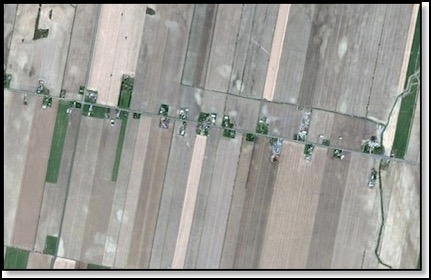
Being a history buff and married to a person who has a Masters in Agricultural Economics and background in transportation, I found this article fascinating to read. In Canada, farms were laid out in ribbon-like pattern along a transportation route. This was developed by Cardinal Richelieu in the 1600s.
The transportation-centric layout of ribbon farms in North America traces its roots back to medieval times. When France was trying to stabilize its colonial foothold in the New World back in the 17th century, Cardinal Richelieu (an adviser to the king and powerhouse in French politics) hatched a plan. To encourage more intensive settlement, he parceled the land similarly to the way it was divided in France: in long, thin strips oriented perpendicularly to a transportation route – which in Nouvelle France was primarily the St. Lawrence River.
This concept was different in the United States where the land was plotted and the transport systems brought to it as described here……
Much of arable North America, however, was not allocated in ribbon farms. The Public Land Survey System carved up large portions of the United States into one square mile sections, each of which were subdivided to create farms and aggregated to form townships. Canada adopted a similar system, the Dominion Land Survey, for its prairie states.
So when the U.S. started with square farms, the process and the results were the exact opposite from ribbon farms: We plotted the farms first and then pondered the logistics. It’s therefore no surprise that Americans feel transportation should come to us instead of the other way around. We pick a place to live and then figure out how to get where we need to go. If no way exists, we build it: roads, arterials, highways, interstates … and so on.
Comments